Zion And Surrounding Area Guide
Loading...
-
-
 State park campground convenient to St. George and Zion.
 -
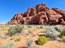
Small, secluded BLM campground near dinosaur footprints and Red Reef trailhead.
-
Petroglyphs on boulders at the Santa Clara River Reserve
-
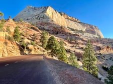 Rt 9 from Springdale winds through the park to the East Entrance Ranger Station
-
 Short, scenic hike that is popular (parking fills fast); dino prints nearby
 -
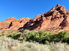
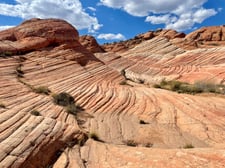 Provides access to the scenic Candy Cliffs area
 -
 Semi-technical wet slot canyon requiring a permit
 -
-
-
-
-
Short trail on Zion scenic drive that leads to an overlook
-
Petroglyphs on boulders at the Santa Clara River Reserve
-
-
Short, scenic hike that is popular (parking fills fast); dino prints nearby
-
Provides access to the scenic Candy Cliffs area
-
Semi-technical wet slot canyon requiring a permit
-
-
-
-
-
Short trail on Zion scenic drive that leads to an overlook
-
Small, secluded BLM campground near dinosaur footprints and Red Reef trailhead.
Loading...
Anasazi Valley trail
Loading...
Snow Canyon State Park
Loading...
Red Reef trail
Loading...
Candy Cliffs (Anna's Viewpoint) trail at Yant Flat
Loading...
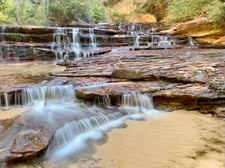
Zion: The Subway trail (bottom up or top down exit trailhead)
Loading...
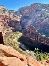
Zion: Angel's Landing trail
Loading...
Zion: Narrows trail
Loading...
Zion: Observation Point via Echo Canyon hike (from Weeping Rock trailhead)
Loading...
Zion: Cable mountain trail (from Stave Spring trailhead)
Loading...
Zion: Canyon Overlook trail
Loading...
Zion: Scenic drive through Mt. Carmel Tunnel
Loading...
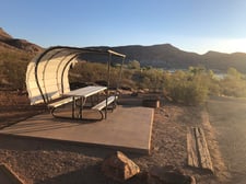
Quail Creek Campground
Loading...
Red Cliffs Campground
Loading...
Last updated: October 21, 2025
Loading...