Zion And Surrounding Area Guide
-
Petroglyphs on boulders at the Santa Clara River Reserve
-
-
 Short, scenic hike that is popular (parking fills fast); dino prints nearby
 -
 Provides access to the scenic Candy Cliffs area
 -
 Semi-technical wet slot canyon requiring a permit
 -
-
-
-
-
Short trail on Zion scenic drive that leads to an overlook
-
 Rt 9 from Springdale winds through the park to the East Entrance Ranger Station
 -
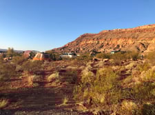 State park campground convenient to St. George and Zion.
 -
Small, secluded BLM campground near dinosaur footprints and Red Reef trailhead.
-
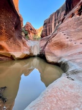
Hike to explore some interesting potholes
-
-
-
-
Gypsum collecting location
Loading...
Loading...
Anasazi Valley trail
Loading...
Snow Canyon State Park
Loading...
Red Reef trail
Loading...
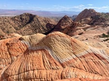
Candy Cliffs (Anna's Viewpoint) trail at Yant Flat
Loading...
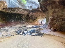
Zion: The Subway trail (bottom up or top down exit trailhead)
Loading...
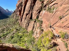
Zion: Angel's Landing trail
Loading...
Zion: Narrows trail
Loading...
Zion: Observation Point via Echo Canyon hike (from Weeping Rock trailhead)
Loading...
Zion: Cable mountain trail (from Stave Spring trailhead)
Loading...
Zion: Canyon Overlook trail
Loading...
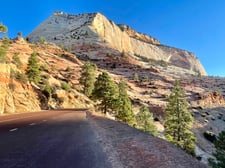
Zion: Scenic drive through Mt. Carmel Tunnel
Loading...
Quail Creek Campground
Loading...
Red Cliffs Campground
Loading...
Zion: Many Pools Trailhead
Loading...
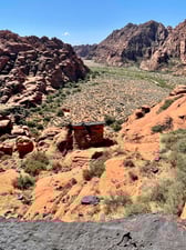
Grafton Ghost Town
Loading...
Sand Cove Trailhead (Babylon Arch, Dino Footprints)
Loading...
Chuckwalla Trail Head to Scout Cave
Loading...
Glitter Mountain
Loading...
Last updated: February 09, 2026
Loading...